


Extreme Rain Impacts on the City of Toronto
- Aug 30, 2016
- 4 min read
Climate change is causing an increase in extreme weather events across the globe observed in the form of extreme rain and flooding, prolonged heat waves, drought, and other weather conditions. This in turn has implications on the natural and built environments, public health, businesses and the insurance sector, global assets, and the wider community of investors. Here at the City of Toronto, 12.1 billion worth of infrastructure and 2.8 million stakeholders are at stake. The City of Toronto Climate Change Risk Assessment conducted in 2010 focused on four subdivisions of the Transportation Services Division (TSD): Infrastructure Operations (IO), Transportation Infrastructure Management Section (TIMS), Traffic Management Centre (TMC), and Engineering and Construction Services (ECS). Each unit is responsible for numerous assets and services which were found to be under the threat of being negatively impacted by climate change. According to the Federation of Canadian Municipalities, nationwide climate change costs could escalate from roughly $5 billion per year in 2020 — less than 10 years away — to between $21 billion and $43 billion per year by the 2050s. [1]
The impact of climate change on the weather is manifested in an increased frequency, duration, and intensity of extreme weather events. The most critical climate change risk events for TSD were found to be extreme rain in the downtown core and extreme heat, city-wide. TIMs is expected to receive the extreme spectrum of extreme rain and heat impacts such as potential structure collapse, road damage, permanent and temporary road closure, and inlet erosion, affecting delivery of utilities and transit services. Due to the urgency produced by the anticipated level of risk (Table 1) the city wide risks to TIMS associated with extreme heat have been examined in 2014 showing a trend of increasing vulnerability of roads, in particular Major, Minor, and Expressway. . The focus of this report is to examine the risks to TIMS associated with extreme rain.
The climate driver study, which focuses on Toronto specific predictions, predicts that total yearly extreme rainfall will increase by 224.1 mm by 2049. A proportion of this increase will be a result of 105.7 mm decrease in yearly snowfall due to daily temperatures being up to 7°C hotter. While there will be fewer days with precipitation over 25mm, the rainfall that will happen during days that receive precipitation will be much more severe. For example, storms that currently happen with a 100 year frequency (>81.2mm of precipitation over a 24 hour period), will happen every 2 to 5 years by 2049. Likewise, the daily rainfall maximum precipitation will increase from 66mm to 166mm. In order to prepare for the impact of extreme rain events on TIMs assets, and the subsequent stakeholders, it is necessary to systematically determine the extent of vulnerabilities temporarily and spatially. This can be accomplished using Geographic Information System (GIS) analyses by weighting different factors that comprise and amplify or diminish a negative impact, such as: life expectancy of the road, drainage system coverage/efficiency, and population density. Effective understanding of the projected changes will be achieved through comparison of extreme rain impact simulation between two time periods: 2010 – 2020 and 2040 – 2050.
[full report can be obtained by contacting the author of this blog]
Results
The catch basins are most concentrated in the East York district, as well as a part of North York. These areas are assumed to be associated with higher drainage and thus a lower vulnerability to Extreme Rain events. Likewise, the watercourse, stormwater infiltration trenches, and ponds mitigate the stormwater thereby decreasing vulnerability of city assets to the effects of extreme rain. Drainage is also affected by the elevation of the area, with lower elevations being more susceptible to flood and erosion, and higher elevation being less susceptible.


Green space increases the overall permeable surface in a city, thus high concentrations represent less vulnerability to Extreme Rains and spaces with a smaller concentration of green spaces are at a higher risk of suffering Extreme Rain consequences. Nonetheless, certain areas of the city are considered environmentally significant areas, thus excess rain is considered damaging.


High concentrations of population, roads, bridges, and culverts with a higher volume and speed, are network characteristics that will increase extreme rain vulnerability. A high concentration of roads with a high Pavement Quality Index (PQI), on the other hand, represents the newer roads, thus decreasing road vulnerability to heavy rains.


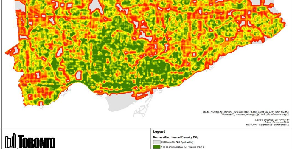


The final maps were obtained after combining the discussed mitigating and aggravating factors. The result was a visual indication vulnerability to extreme rain damage in different parts of Toronto.

This result can be compared to a map projected for years 2040 to 2050 assuming a 25% decline in pavement quality.

A network-wide medium level risk to extreme rain events is observable in Toronto. This risk is expected to increase with an increased incidence of extreme rain events and a declining quality of pavement. The maps show which areas might require a higher level of attention and allocation of funding.
[full report can be obtained by contacting the author of this blog]
Comments